At SkyMap Global, our mission is to help businesses and government agencies leverage remote sensing technology to gain critical insights while keeping it affordable yet efficient.
Our team built a solution for the state government of Arunachal Pradesh that leverages satellite imagery, the internet and the power of a smartphone to help personnel monitor infrastructure developments in the state.
This web-based infrastructure monitoring solution is a game-changer for the government to monitor progress in infrastructure in a terrain that is difficult to traverse.
Understanding Arunachal Pradesh’s terrain
Arunachal Pradesh is located on the hilly terrains of the Himalayan range with winding roads and inaccessible areas. This makes it impossible to monitor the physical development of projects by ground survey and is a daunting task for the state government. Some of the villages are located in remote and inaccessible areas, which are not connected by road.
Mule tracks or porter tracks are the life-line of these remote villages. Men and material including lifesaving drugs and rations are transported through head load by Auxiliary Labour Corps or ALCs as they are popularly known in this part of India. It takes days to reach those villages by foot march. Given the situation, getting ground assessment of infrastructures development is arduous and time consuming.
Arunachal Pradesh also has the longest international boundary amongst the North-Eastern states. Monitoring of infrastructure or projects has been a crore issue of challenges for the state government. The State Planning Department currently monitors projects through a third party monitoring system and since the state has no source of its own revenue generation, it can hardly afford the financial, logistics support required to manage the monitoring system.
The Government of Arunachal Pradesh is also implementing various developmental projects such as NEC, PMGSY, RIDF, NABARD, NLCPR, IWMP and more, which are to be monitored for successful implementation and to achieve targets set forthwith.
Monitoring infrastructure remotely
An idea was mooted to monitor projects with a satellite based monitoring system with the theme, “Arunachal Pradesh – No Longer Remote with satellite based remote sensing technology,” which can overcome current physical and monetary limitations.
Using satellite imagery, the state planning department could monitor progress and help send the right reports to state government on a timely basis. The solution would also help the state government to detect mismatch of funds sanctioned for any project. The solution would also help to identify projects of the same nature in the project sites and eliminate duplicity.
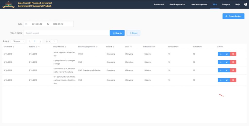
A Management Information System (MIS) module would help the Department of Planning & Investment to create its own database on the physical progress and financial achievements of developmental projects from time to time. Thus, the State Remote Sensing Application Centre, Government of Arunachal Pradesh, in collaboration with SkyMap Global designed a solution that integrated high resolution satellite imagery, GIS and MIS on a single platform to offer a complete end-to-end monitoring solution.
Implementation
Project Identification and Geo-tagging
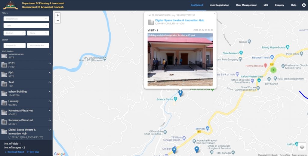
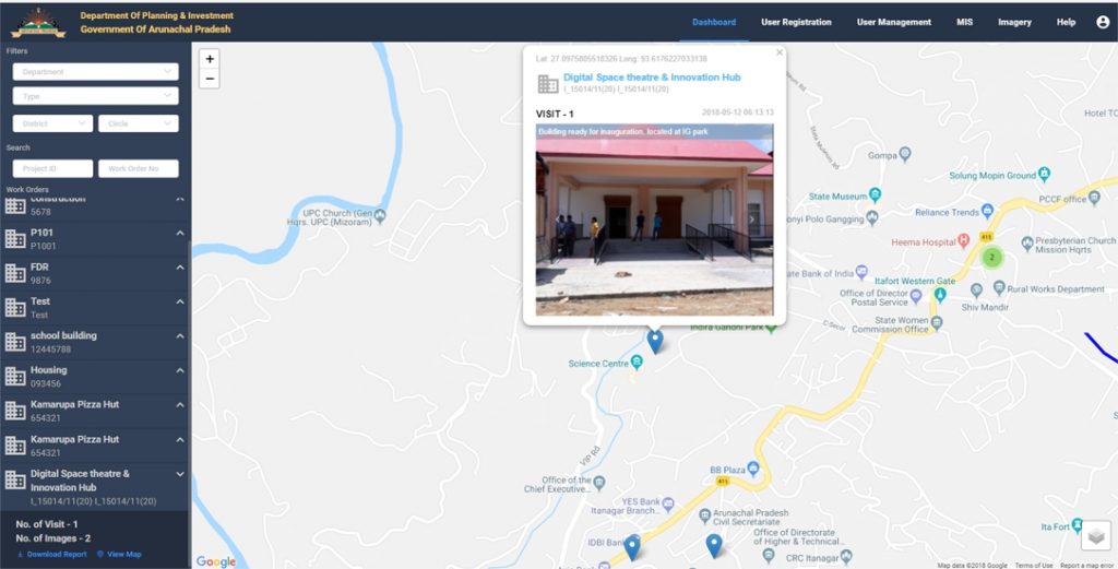
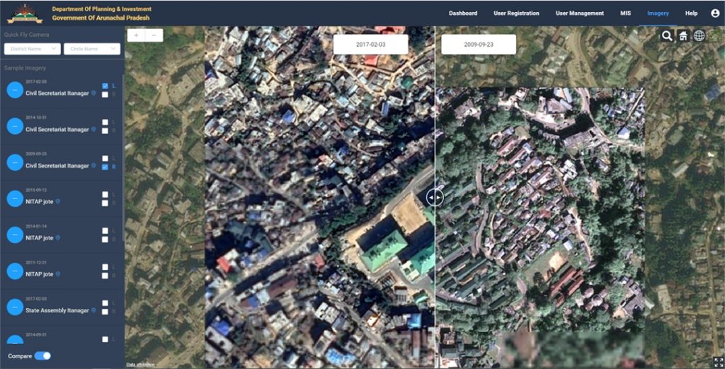
Using satellite imagery, projects were identified and geo-tagged. A web interface was developed where these geo-tagged projects could be viewed on a vector map. A comparison interface could help the user check progress or change in a project over a period of time.
Android App for Field Survey and Reporting
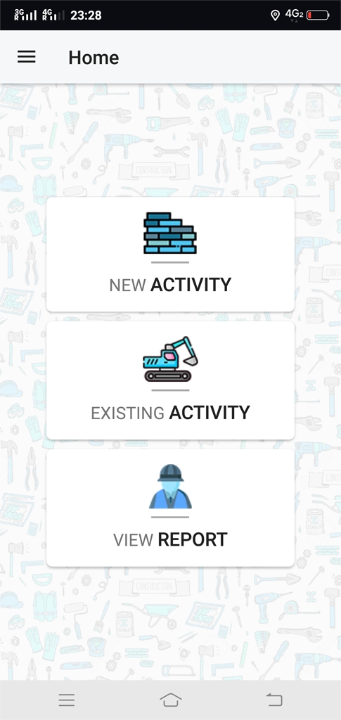
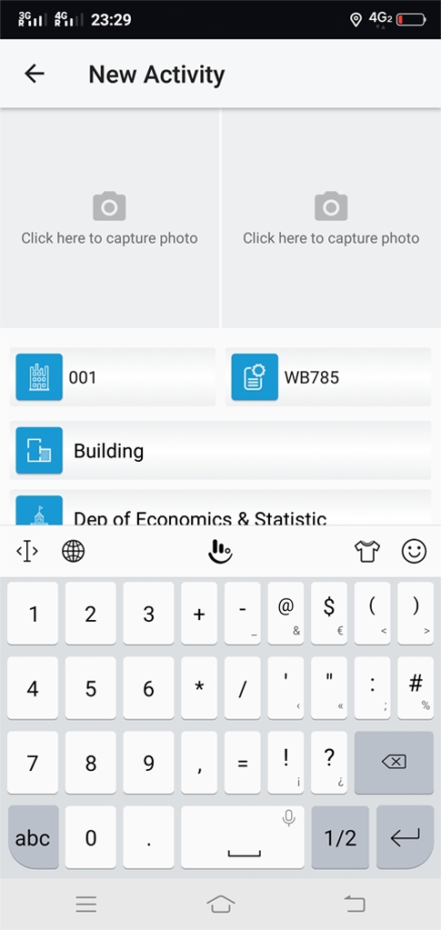
A GPS enabled Android based smart phone application was developed for collection of field information from work sites. The application is useful to report the field situation, capture images, collect Geo- Codes (Lat & Long Coordination), archives and relay field information. Photos of work sites are added to the pro- ject information. This has helped update the progress of projects on a day to day basis. More importantly, all this field information pertaining to a project can be attached to that project. This can then be viewed on the map.
Integrated Management Information System (MIS)
A MIS system was built and integrated into the web tool so that the Planning Department could update fund utilisation, progress and change detection status on ground that is associated with a project and geo-tagged.

What Arunachal Pradesh gained from employing this solution
- This approach provided support to administrators, Planners, Data Providers, Field level personnel and also for general public towards creating, visualising, analysing as well as assessing the progress and status of works and its activities.
- Monitoring infrastructure remotely helped the state government do away with training of enumerators and conducting sites visit as these are time consuming, resource intensive and involves reengaging security forces to provide security to field officers.
- The solution has given an interface between the State Government and Citizens to view any Geo-tagged photos near specific location, providing project status information.
- The solution also empowers the state government in its mission to contain unprofessional conduct during the execution of the project.
This solution brings transparency and accountability amongst multiple stakeholders. Inbuilt artificial intelligence and data analytics in Dashboard would able to trace the reasons for delay of projects and other pending issues like non-submission of UCs in time.
Custom developed for Arunachal Pradesh, the Dashboard generates an alert SMS/Email to be sent to concerned agencies for immediate necessary action. Real-time information received via Android GPS enabled smartphones is displayed on the dashboard. Site images captured by field personnel is also shown to facilitate quick decisions at all levels.
This new initiative aided performance measurement and provide updates on status and challenges found during execution of projects. For Arunachal Pradesh, this solution is a path-breaking initiative.
Performance status of each department would be updated constantly from each districts through Deputy Commissioner and District Planning Officers enabling the highest offices of the state government to monitor and facilitate timely execution.
The solution would create a global platform for all stakeholders to share, retrieve and store their geospatial data and act as backbone for quick decision support system for the planners and other decision makers.
Screenshots from the solution
Testimonial
On behalf of entire team from State Remote Sensing Application Centre, Arunachal Pradesh, I extend my deep gratitude to the technical team of SkyMap Global for working very hard on development of the Monitoring Dashbaord, an automated centralised web based application to aid the process of monitoring of all developmental projects in Arunachal Pradesh.
We here at SRSAC finds the Dashboard enabled web portal named as “Arunachalmonitoring.com” easy to use with simple, smooth & quick user interface. Viewing developmental projects and its activities in dashboard is really useful and we can see the images and details uploaded from mobile application instantly.
It has value addition in terms of filtering and search option, which is provided in dashboard to make it easier for data entry operators and users. The map image quality of dashboard is better than Google Earth and any other online websites.
Data entering and processing information in MIS has really ceased the daily work of record maintaining and retrieving information. Earlier data and information were kept and stored in different hard files and computers but MIS in webportal has provided a common platform where users can upload and retrieve information easily and from any location.
The beauty of this dashboard is provided imagery option which has proved to be useful, specifically the compare option to compare the differences and changes happened in a particular areas of work sites.
Tana Tage,
Deputy Director (Planning/HQ) Cum Nodal Officer,
State Remote Sensing Application Centre,
Government of Arunachal Pradesh
To learn more on the Infrastructure monitoring solution, contact us
Thanks a lot very much for this specialized and sensible help.