CROP INSURANCE
SkyMap Global offers reliable agri-intelligence information through estimated data on crop acreage, yield and crop conditions to stakeholders of agriculture that includes crop advisors, input companies, planners, insurance companies and policy makers. This information supports in understanding, planning and for taking decisions across the agri value chain, farm and crop care post harvest care, storage, marketing and other farming related issues
SkyMap Global offers reliable agri-intelligence information through estimated data on crop acreage, yield and crop conditions to stakeholders of agriculture that includes crop advisors, input companies, planners, insurance companies and policy makers. This information supports in understanding, planning and for taking decisions across the agri value chain, farm and crop care post harvest care, storage, marketing and other farming related issues
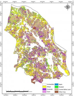
Crop classification for spatial distribution and acreage estimation
SkyMap Global can help classify crops for different seasons and for different crops grown over seasons in farm lands, which can further be used for crop monitoring and crop growth over seasons. Our AgriTrekk Application is used for agriculture survey and data collection at ground level, reducing time of data collection and processing. Using Agritrekk App, the field data can be processed on real time basis and estimate crop acreage at different administrative unit level. Understand the status of crops cultivated and uncultivated area for planning, and pre-harvest preparatory actions during worst weather conditions, sudden pest attacks, and making premium policies pertaining to crop.
Crop classification for spatial distribution and acreage estimation
SkyMap Global can help classify crops for different seasons and for different crops grown over seasons in farm lands, which can further be used for crop monitoring and crop growth over seasons.
Our AgriTrekk Application is used for agriculture survey and data collection at ground level, reducing time of data collection and processing. Using Agritrekk App, the field data can be processed on real time basis and estimate crop acreage at different administrative unit level.
Understand the status of crops cultivated and uncultivated area for planning, and pre-harvest preparatory actions during worst weather conditions, sudden pest attacks, and making premium policies pertaining to crop.
Crop yield and production estimation
Forecast crop yield and estimation production of the identified crop in a region. Because of the demand for crop insurance, which increases the need for field level yield statistics, these predictions warn decision-makers about the potential reduction in crop yields and allow timely import and export decisions.
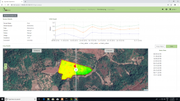
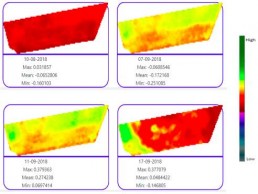
Crop condition monitoring
Using our Agritrekk Application, facilitate real-time crop vegetation index monitoring, to track positive and negative dynamics of crop development, and trend of their growth. Now you can Monitor your entire agriculture farm, and reduce labour intensive monitoring work. Track which farmer is performing well, or which farmland is going through insecticide.SkyMap Global provides disaster loss estimation area, and fixed compensation based on damaged area to help you make the best decisions.
Crop condition monitoring
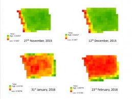
Using our Agritrekk Application, facilitate real-time crop vegetation index monitoring, to track positive and negative dynamics of crop development, and trend of their growth.
Now you can Monitor your entire agriculture farm, and reduce labour intensive monitoring work.
Track which farmer is performing well, or which farmland is going through insecticide.
SkyMap Global provides disaster loss estimation area, and fixed compensation based on damaged area to help you make the best decisions.
Damage Assessment
SkyMap Global uses remote sensing and GIS techniques to access and map pre and post disaster scenarios, presenting them in forms of maps, graphs and charts for visualization and decision making purposes.
Damage Assessment
SkyMap Global uses remote sensing and GIS techniques to access and map pre and post disaster scenarios, presenting them in forms of maps, graphs and charts for visualization and decision making purposes.
Harvest Monitoring and planning
SkyMap Global provides daily monitoring solutions from sowing to harvest. Using remote sensing techniques, understand when the crop is sown through the harvesting, and know which farm plot are double or triple crop.
Harvest Monitoring and planning