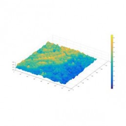
Digital Elevation Model
A DEM is made of discrete elevation points at evenly spaced intervals. As DEMs can be extracted from stereo satellite imagery, it is possible to get models of remote places. DEMs are used in various applications, from land use planning to agricultural zoning.
A DEM is made of discrete elevation points at evenly spaced intervals. As DEMs can be extracted from stereo satellite imagery, it is possible to get models of remote places. DEMs are used in various applications, from land use planning to agricultural zoning.
SkyMap DEM Services
SkyMap Global utilizes stereo satellite imagery to produce the Digital Elevation Model (DEM). Data can be from various stereo satellite sensors including the Kompsat 3A (0.4m) and many other commercially available data. High-resolution data will be able to support project planners, operation managers, and logistics managers to plan field operations in a computer environment, ensuring that the best terrain conditions and access are provided to achieve project objectives.
SkyMap DEM Services
SkyMap Global utilizes stereo satellite imagery to produce the Digital Elevation Model (DEM).
Data can be from various stereo satellite sensors including the Kompsat 3A (0.4m) and many other commercially available data. High-resolution data will be able to support project planners, operation managers, and logistics managers to plan field operations in a computer environment, ensuring that the best terrain conditions and access are provided to achieve project objectives.
GET YOUR FREE IMAGE PREVIEW REPORT
A member of our team will contact you for clarification, following which you will receive your free image preview within 2 working days.