Work with a Google Maps APIs Premier Partner
We are a Google Maps Premier Partner with immense experience in implementing Google Maps APIs successfully across a wide spectrum of industries. Let's talk about how you can harness the power of Google Maps to innovate and differentiate your business offering.
Get Free Consultation and Support
Get Google Maps API Licensing
Integrate Google Maps in your Apps
How we can help you use Google Maps API
Here are some examples of how you can leverage the power of Google Maps for your products and services
Fleet & Asset Tracking
Reduce operating costs through optimized routing and better asset visibility. Predict travel time between points based on historical data and current condition traffic. Tracked entities can include people, vehicles or any moving assets. You can group assets into collections and associate collections with geofences (regions of interest).
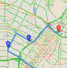
Last Mile Delivery & Route Optimization
Track and locate your couriers in real time with traffic updates, adding a new layer to their calculated routes lengths and current job locations. Receive automatic alerts and newly calculated routes in real-time, when traffic conditions and estimated delivery times change.
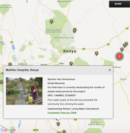
Data Visualisation
With our core competency being Satellite imagery and services, we can help your business tell a more powerful story with your own location-based data and empower your users to get involved. Show specific data at specific locations on the map. Data can come from Satellite imagery and other sources.
See how businesses are using Google Maps APIs


Madras Cements
See how Madras Cements uses Google Maps to visualize business data and glean insights from reports, allowing them to pinpoint strategies for business growth.
Madras Cements
See how Madras Cements uses Google Maps to visualize business data and glean insights from reports, allowing them to pinpoint strategies for business growth.
When do you need to choose a Google Maps Premium Plan?
A Google Maps license will give you the ability to embed maps and visualize your own data in layers. Featuring a host of APIs for both the Web and Mobile, a premium plan is best suited:
- When using an app internally or as part of a restricted user group eg. CRM
- To charge users for using your application
- Build tracking applications that monitor assets such as trucks, cars, etc.
- To get higher application up-time
- For dedicated technical support
Google Maps APIs
Learn more about all the Maps APIs that are available for use in your offering
Android API
Add Google Maps to your Android Apps. The API automatically handles access to Google Maps servers, data downloading, map display and response to map gestures. You can also mark locations, path and borders on your map.
Places API for Android
Add device place detection, autocomplete and up-to-date, detailed information about places across a wide range of categories to your Android app
Google Maps SDK for iOS
Add Google Maps to your iOS apps. The API automatically handles access to Google Maps servers, data downloading, map display and response to map gestures. You can also mark locations, path and borders on your map.
Places API for iOS
Add device place detection, autocomplete and up-to-date, detailed information about places across a wide range of categories to your iOS app.
JavaScript API
Build highly customizable maps with your own content and imagery. Create rich applications and stunning visualizations of your data, leveraging the comprehensiveness, accuracy and usability of Google Maps and a modern web platform that scales as you grow.
Embed API
Bring the power & convenience of Google Maps to your website with simple HTML. Help your users discover places using their own personalized map, tapping into Google’s rich database of over 100 million places worldwide.
Street View Image API
Embed a Street View image on your site. Works similarly to the Street View Service in Google Maps Javascript API. Specify latitude/longitude or a panorama ID to pick your location and determine the direction of the scene and angle of the camera.
Static Maps API
Embed a Google Maps image on your web page without requiring JavaScript or dynamic page loading. The Google Static Maps service creates your map based on URL parameters sent through a standard HTTP request and returns the map as an image you can display on your web page.
Geocoding API
Find latitude/longitude coordinates for a given address
Places API Web Service
Find detailed information about over 100 million places across a wide range of categories. Add server-side features to your native client application.
Geolocation API
Find the location of your visitors. The Google Maps Geolocation API returns a location and accuracy radius based on information about cell towers and WiFi nodes that the mobile client can detect. It is primarily used in devices that don’t feature a GPS.
Directions API
Calculate direction between locations. Search for directions for several modes of transportation, include transit, driving, walking or cycling.
Distance Matrix API
Provide travel distance and time for a matrix of origins and destinations. The predictive travel time feature uses historical time-of-day and day-of-week data to help determine the best driving or public transit route and the how long the trip will take.
Roads API
Improve data visualization through specific capabilities such as snap-to-road and speed limits.
Time Zone API
Get time offset data for locations on the surface of the earth
Elevation API
Query locations on earth for elevation data. Get elevation data for all locations on the surface of the earth, including depth locations on the ocean floor.
Contact us for information on the Google Maps API
Please fill out the form below to schedule an appointment