About Us
INDUSTRIES
AGRICULTURE
SMART CITY
FORESTRY
INFRASTRUCTURE
MINING
SERVICES
BASEMAP
SATELLITE
SMART CITY
DRONE
GOOGLE MAPS API
DIGITAL ELEVATION MODEL
MAPPING & SURVEYING
DIGITAL MAPPING
INFORMATION LAYERING AND GIS IMPLEMENTATIONS
MONITORING SERVICES
AI/ML SERVICES
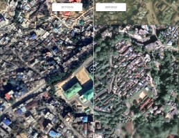
CHANGE DETECTION
SOLUTIONS
SALESTREKK
AGRITREKK
FORESTREKK
INFRASTRUCTURE MONITORING
EVENTS
BLOG
CAREERS
CONTACT
Search
case study
June 19, 2018
Infrastructure Monitoring – A Case Study
by Santosh Subramanian