Features
Keeping a Watch on Forest and Biodiversity for Sustained Growth
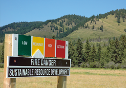
Forest Fire Monitoring
Automatic update of forest fire location into server along with weather information. This information helps to get fire location and further projects the direction of fire as well as profiling the daily update. System can store long term fire locations to build historical instances of fire.
Hotspot Validator
Locate every hotspot on Mobile through this application. Field executive can Navigate Hotspot Location with his current location using google map within the territory and validate with photograph and description that are updated to server. These are all managed within the application.
Fire Monitoring via Web and Mobile
Integrate it with Hotspot Validator mobile application for registration. Gather field level information and confirm fire location while going through the forest or any other area. Check statistics with location information in Google Maps.
Fire Monitoring via Web and Mobile
Integrate it with Hotspot Validator mobile application for registration. Gather field level information and confirm fire location while going through the forest or any other area. Check statistics with location information in Google Maps.
Daily Coverage
High resolution Satellite images collected within the Organization for the area of interest and updated into server. There is a Flexible option to filtering based on satellite, resolution, Cloud, tilt angle so as to minimize effort and time. Polygons can be drawn into server to search selective location per representative choice.
Encroachment and Illegal Logging Monitoring
Deforestation is a major cause of the loss of forests around the world. According to the United Nations Framework Convention on Climate Change (UNFCCC), forest encroachment for agriculture is the main reason for deforestation, followed by logging and fuelwood removal.
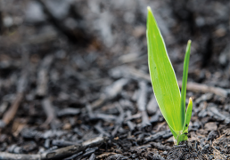
Plantation Monitoring
Forest plantations are expanding and monitoring extent is critical for understanding environmental and socioeconomic impacts. In ForestTrekk Platform we have integrated AOI management where you can save those areas and check with every day high-resolution imagery within the platform if required you can download images.
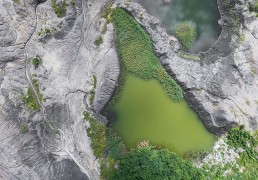
Burnt Area Assessment
Forest fire is a major cause of degradation of forests. After the fire finished it is very necessary to estimate the loss. ForestTrekk solution is made with an integration of hotspot location with daily coverage of imagery within the same platform, it’s very easy to simulate and Map Burnt area. Fire affected areas can be discriminated in a remote sensing image due to the strong contrast with the unburned areas. Burn scar maps derived from remote sensing images provide information on the spatial extent and distribution of the fire affected areas, and the total area burned for assessment of fire damage to the economy and environment.