Forestry
Earth observation and analytics solutions for Forestry
Home / Your Industry / Forestry
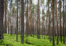
Being a renewable resource, forest cover can be regenerated through sustainable management. Hence, with the help of remote sensing and GIS data, a forest manager can generate information of forest cover, types of forest present within the area of the study, human encroachment into forest land/protected areas, encroachment of desert-like conditions and so on. This information is critical in the development of forest management plans and in the process of decision making to ensure that effective policies have been put in place to control and govern the manner in which forest resources is utilised.
Forest Encroachment Monitoring
Deforestation is a major cause of the loss of forests around the world. According to the United Nations Framework Convention on Climate Change (UNFCC), agriculture is the main reason for deforestation, followed by logging and fuelwood removal.
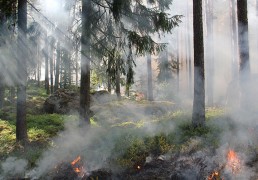
Forest Fire Monitoring
The increasing rate of occurrence of forest fires has increased the concern over their impacts on climate change and fragile ecosystems. This requires efficient and effective methods for forest fire detection for near- real time monitoring so as to minimise these impacts.

Forest Health Monitoring
Tree health is a critical parameter for evaluating urban ecosystem health and sustainability. Monitoring urban forest tree health has recently relied on vegetation mapping of urban forest using remote sensing.