AI/ML SERVICES
Fast Digital Map
Update and generate most current data on maps using artificial intelligence and machine learning. Eradicate the labour intensive and time consuming process of updating and generating digital maps.
Change Detection
Automatically detect changes, and get highlighted area of change that has taken place
Information overlay and extraction for smarter decision making
Extract building footprint and add information such as building ownership, mortgage information, building height lat long and address.
Building Footprint Extraction
Harness the power of Artificial Intelligence and extract accurate 2D building footprints within any given area. Our platform has the capability to deliver approximately 8,000 buildings per hour
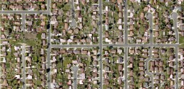
Building Footprint Extraction
Harness the power of Artificial Intelligence and extract accurate 2D building footprints within any given area.
Our platform has the capability to deliver approximately 8,000 buildings per hour
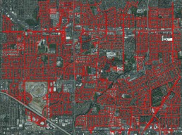
Road Extraction
Save costs with us as our solution can run on medium resolution (3m) satellite imagery with an accuracy of up to 90%. With the help of artificial intelligence - derive actionable insights to better map, monitor and manage roads.
Road Extraction
Save costs with us as our solution can run on medium resolution (3m) satellite imagery with an accuracy of up to 90%.
With the help of artificial intelligence - derive actionable insights to better map, monitor and manage roads.
Forest Area Extraction
Automatically extract forest area information to gain insights on the tree covered and forested areas. Understand the loss of biodiversity and carbon sequestration. We offer short-revisit cycle satellite image technology to help monitor activities such as deforestation and encroachment.
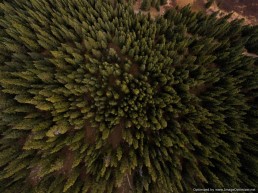
Forest Area Extraction
Automatically extract forest area information to gain insights on the tree covered and forested areas.
Understand the loss of biodiversity and carbon sequestration. We offer short-revisit cycle satellite image technology to help monitor activities such as deforestation and encroachment.
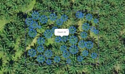
Tree Counting
We have developed proprietary algorithms to help automatically detect and count trees in any given area.
Tree Counting
We have developed proprietary algorithms to help automatically detect and count trees in any given area.
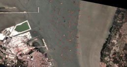
Ship Detection
Detect ships and vessels in your area of interest (near-shore, open ocean). Extract important information such as the size, location and the direction they are heading. The multitude of services we offer -
Vessel detection Full AIS information extraction Customized alert for unknown activities Information layer on vessels
Ship Detection
Detect ships and vessels in your area of interest (near-shore, open ocean). Extract important information such as the size, location and the direction they are heading.
The multitude of services we offer -
Vessel detection Full AIS information extraction Customized alert for unknown activities Information layer on vessels
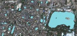
Water Boundary Extraction
Automatically detect and extract seasonal water bodies and monitor change over an extended period of time.
Water Boundary Extraction