DRONE IMAGERY
What is drone imagery?
Today’s rapidly growing economic and cultural landscape demands the use of high-resolution UAV Imagery and cutting-edge remote sensing. This is crucial for leaders in governments and private enterprises to make the right decisions. From economic development to disaster management, infrastructure to national security, information is power. At SkyMap Global, we’re excited to announce the launch and availability of the UAV platform that we call “G-Wing” for affordable and efficient high-resolution mapping, remote sensing and surveillance. Our goal with G-Wing is to empower people and leaders from the government, it’s agencies and private enterprises with access to high-resolution imagery and insights so that they can respond to situations faster than ever before.
What is drone imagery?
Today’s rapidly growing economic and cultural landscape demands the use of high-resolution UAV Imagery and cutting-edge remote sensing. This is crucial for leaders in governments and private enterprises to make the right decisions. From economic development to disaster management, infrastructure to national security, information is power.
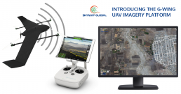
At SkyMap Global, we’re excited to announce the launch and availability of the UAV platform that we call “G-Wing” for affordable and efficient high-resolution mapping, remote sensing and surveillance.
Our goal with G-Wing is to empower people and leaders from the government, it’s agencies and private enterprises with access to high-resolution imagery and insights so that they can respond to situations faster than ever before.
One of biggest problems with small drones is the risk of crash or loss during operation. The risk is quite high leading to an eventual effect on the company profitability and productivity. G-Wing’s systems reduce the risk of hard landing during operation and feature an extra fail-safe system during cruising mode. So, we’re increasing drone lifespan, lowering maintenance cost and maximising the size of mapping coverage.
With G-Wing, we’ve also addressed the issue of space requirements, especially during takeoff and landing. Finding the right spot for drone operation can be a cumbersome task. With that in mind, we’ve designed the G-Wing to be launched and retrieved autonomously in a very tight area of 3m x 3m to enable operations in dense forest area, plantation, dense urban areas and even from a boat deck.
The VTOL transitional algorithm has been completely programmed in-house by our experienced drone engineering team. Before we commercialised, we spent time testing over hundreds of flight hours to improve the aircraft’s aerodynamic stability, efficiency and performance. To make the G-Wing reliable, durable and robust, we chose the best avionics firmware for endurance mapping and surveying flight missions.
We’ve also included a fail-safe option for takeoff and landing which can be accomplished in two ways – manual radio transmitter control or autopilot assisted control.
With around 200 grams of payload support, G-Wing can be mounted with a wide range of cameras including a Sony RXO, Garmin GPS, FLIR Duo Thermal Camera, MAPPIR (NDVI) and other Cameras or GPS/RTK/PPK devices with compatible mounting brackets. G-Wing comes with a Flexiload system that helps change multiple options of payload between flights.
Imagery from G-Wing is processed and put on our ImageTrekk platform which can help you discover, visualize and analyze data to gain deep insights.
Powered by machine learning routines and artificial intelligence tools, ImageTrekk takes in data from a multitude of sources, analyzes the data in accordance and relevance to your imagery and overlays that for a faster workflow.
G-Wing can be fully operated and controlled from G-Station – A user friendly laptop or tablet application.
The G-Wing drone is a hybrid VTOL (Vertical Takeoff & Landing) UAV, combining the benefits of multi-rotor platforms with fixed-wing drones and easily enables transition between the two modes during flight. It is a modular, lightweight, forward wing professional mapping and surveying drone that comes built-in with an autonomous GPS guided system. We’ve also equipped it with a Flexiload system to support multiple options of payload between flight operations.
The G-Wing drone is programmed to fly at certain altitudes and Airspeed to capture precision images at predetermined waypoint intervals. Specifications are outlined below. Our G-Wing drone takes shape after years of experience in testing and operating mapping drones.


