AGRICULTURE INTELLIGENCE
SkyMap Global has developed agriculture information system (AIS)using AI/ML techniqueson different data sources,to generate a spatial database of agriculture attributessuch as crop type and land use land cover.The databases generated are mapped, analyzed and monitored using applications
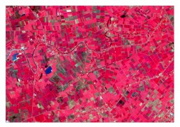
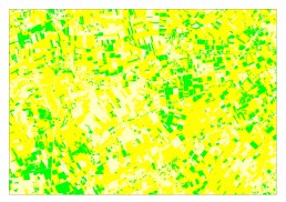
Crop Mapping
SkyMap Global can help you use satellite image classification techniques and models to differentiate crops and to map the spatial extent of crops. Using our Machine Learning algorithms, map crop extent in a short turnaround time. We use our very own drone based images and processing technique to map and monitor crops!
Crop Mapping
SkyMap Global can help you use satellite image classification techniques and models to differentiate crops and to map the spatial extent of crops. Using our Machine Learning algorithms, map crop extent in a short turnaround time.
We use our very own drone based images and processing technique to map and monitor crops!
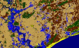
Land use land cover mapping
Using our high resolution satellite images, map land use and land cover from level 1 to level 3 classification.Map detailed classes of agriculture and forest of a particular region.
Land use land cover mapping
Using our high resolution satellite images, map land use and land cover from level 1 to level 3 classification.
Map detailed classes of agriculture and forest of a particular region.
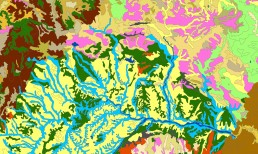
Baseline land mapping for physiography
Using our GIS techniques along with criteria based models, map spatial extent of landforms or physiography of a region. Derive contours, slope and elevation information for any of your use cases.
Baseline land mapping for physiography