CHANGE DETECTION
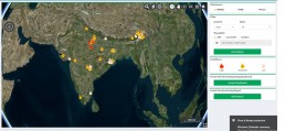
Detect Forest Fire and assess extent of damage
Forest fires have become an environmental concern in recent years posing a threat to human life and property and our natural environment. Near real-time satellite observation data help officials detect and monitor forest fires, fire patterns, and assess damage in burnt areas. SkyMap Global’s application on Forest Fire Detection and Monitoring System uses real-time data to identify the affected areas, provide unit-wise level fire count statistics.
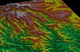
Forest Land cover change monitoring
The changes in forest cover are the matter of global concern due to its ability of promoting role in carbon cycle. Our Automated classification approach in time series satellite images are used to map and monitor forest cover change. SkyMap Global uses the short revisit cycle satellite imaging technology, to monitor forest data, in particular deforestation and encroachment. This helps in understanding the loss of biodiversity and reduction of carbon sequestration
Forest Land cover change monitoring