Webinar: Remote Monitoring with Satellite Imagery
See how you can harness satellite imagery with advanced tools to get automated insights for application in your industry.
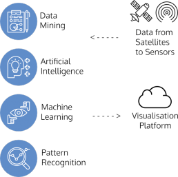
At SkyMap Global, our mission is to help you uncover insights from satellite and aerial imagery. Powered by artificial intelligence and machine learning, we have built efficient and affordable tools that you can use to extract meaningful information for analysis. Uncover insights and discover factors that contribute to economic change and discover/uncover new emerging markets.
In this webinar, we will demonstrate how you can:
- Accurately identify roads
- Detect building footprints
- Detect built-up area and more.
The webinar will help you discover ideas on how you can harness cloud computing power and automated routines to harness the full value of a satellite or an aerial image.
In this webinar..
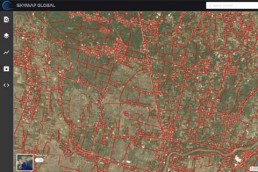
Building Footprint Detection
Easily detect infrastructure and classify by building or project type from imagery. By employing advanced deep learning routines, we have automated the process of extracting 2D footprints with accurate geometrical edges. Do away with outdated data and expensive data collection workflows for your app- lication. Easily monitor projects and detect change for any region.
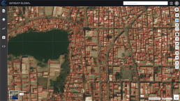
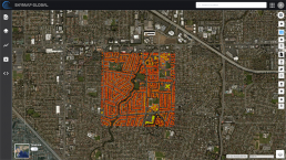
Built-up Area Detection
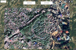
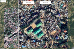
Harness high resolution imagery, cloud computing power and automated monitoring routines to get reports on changes in built-up area automatically.
- Get timely reports with change detected and marked automatically
- Get insights into new built-up area, expansion, encroachment
- Plan resource and utilities allocation based on expansion over time
- Make the right decisions affordably and efficiently
Road Detection
Using the road detection algorithm, you can accurately identify roads and road networks from high resolution imagery automatically. With automatic change detection, you can also identify road construction changes over time in specific regions or at scale. All of this powered by advanced computing techniques.
- Identify roads and road networks automatically
- Plan and manage growth and development
- Prioritise and plan response during chaotic, emergency or disaster situations