CLIMATE CHANGE
SkyMaps unique combination of domain expertise and machine learning analytics provides consulting solutions to government and private enterprises involved in agriculture. We provide solutions to issues like food security, sustainable livelihood development, climate smart agriculture, impact of agriculture forest and other land use (AFOLU) on climate
SkyMaps unique combination of domain expertise and machine learning analytics provides consulting solutions to government and private enterprises involved in agriculture. We provide solutions to issues like food security, sustainable livelihood development, climate smart agriculture, impact of agriculture forest and other land use (AFOLU) on climate
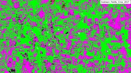
Cropping pattern change assessment
SkyMap Global helps you map and assess cropping pattern change. Comparative analysis is also performed between historical years and current year to assess change in cropping pattern. Use this knowledge to help you make the best decisions for your crops.
Cropping pattern change assessment
SkyMap Global helps you map and assess cropping pattern change. Comparative analysis is also performed between historical years and current year to assess change in cropping pattern. Use this knowledge to help you make the best decisions for your crops.
Deforestation, Degradation and Forest Change Mapping
Climate change has impacted agriculture with respect to area sown under particular crop, change in yield due to change in climate and soil properties. Deforestation, land degradation and change in forest extent are important parameter that SkyMap Global can help to assess the impact on agriculture and livelihood of farmers
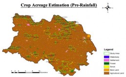
Damage Assessment
SkyMap Global uses remote sensing and GIS techniques to access and map pre and post disaster scenarios, presenting them in forms of maps, graphs and charts for visualization and decision making purposes.
Damage Assessment