Base Image
IMAGETREKK @Baseimage 2017 on Demand
SkyMap Global offers the latest 2017 TRIPLESAT high resolution Satellite Imagery colour coded ortho-rectified Basemap. The Basemap has the latest Satellite Imagery with near complete coverages to provide an impartial picture of what’s on the ground. This will allow user to understand, monitor and make decision on governmental and commercial national or state level projects. Users have the option purchase ImageTrekk web based platform for easy to access to the Basemap and other existing layer; the Basemap can also be access via most commercial or open source map server.
GET A FREE IMAGE PREVIEW REPORT
Test Drive Now
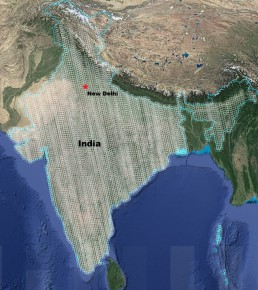
Base Coverage Of India
Test Drive Now!
Click here to test drive: http://imagetrekk.com/karnataka.html
Or Scan the QR code to test drive on your device.

Product Specification
| Data Source | Triple Sat |
|---|---|
| Product Option | Pan-shrpen/Ortho Mosaic Colour Balancing Seamless Cutline |
| Year for image selected | Jan to May 2017 |
| Ground sample distance | 0.8 m(Pan-sharpen) |
| Cloud cover | Less than 15% |
| Off Nadir Angle | +/- 25 |
| Ortho Mosaic | Using 10m DEM |
| License | Single User License |
| File Format | JPEG Tiles |
Why Use Base Image?
Here are some reasons to use Base image from High Resolution Satellite Imagery
- Quick generation of the base maps in comparison with the ground survey methodology. Cost effective so that updates can be acquired on a regular basis.
- Precise identification and delineation of city geographical features/ infrastructure for preparation of the base map.
- Very High Resolution up to date land use maps showing residential, commercial, institutional, industrial, administrative areas along with open/vacant land, water bodies and natural drainage channels that can be generated from the satellite data.
- Delineation of the water supply network and sewerage network by identi cation of the lanes and by-lanes of the city.
Where To Use Updated Base Satellite Imagery?
- Urban Planning & Development for LULC mapping and monitoring.
- Forestry for boundary marking and monitoring Afforestation & Deforestation, Mining & Logging.
- Municipal Development corporation for zone map, ward map boundary and infrastructure identification.
- Water and Sewerage for network mapping.
- Fisheries for water bodies, pond etc.
- Irrigation for Flood and Inundation mapping.
- Smart City Projects for asset mapping and monitoring.
- WPower & Energy for current Tower (EHT,HT,LT) line mapping and monitoring.
- Agriculture for parcel mapping seasonal crop Identi cation and monitoring.
- Disaster Management for mapping and monitoring the affected area.
- Planning and Public Works for departmental planning and infrastructure monitoring of departmental works.
GET YOUR FREE IMAGE PREVIEW REPORT
A member of our team will contact you for clarification, following which you will receive your free image preview within 2 working days.